Sunday 20 March 2016

Walk 224

Dunbar to Cockburnspath 15miles

Blue skies abound at the start of todays walk and even though I had put myself through the ringer yesterday the legs and feet were feeling great.

Dunbar Castle
Even though there isn't much left of Dunbar Castle its still looks very picturesque perched on top of the big rock over looking the harbour.
         The John Muir Way will take me all the way along the coast to Cockburnspath where it meets up with the newly formed Berwickshire Coast path.  I made my way out of Dunbar via the golf course and stood watching some golfers tee off and by some sort of miracle all 3 of them managed to find the water with their first shot! I was crying with laughter inside!!!
          The path hugged the coast and I was soon at the impressive Barns Ness Lighthouse.

Barns Ness Lighhouse
            I wound my way in and out of various bays and eventually I arrived at my final nuclear power station of my 5000 mile walk at Torness Point, like always I tried to hold my breath as I walked round the carbuncle!! I soon had my back to the power station and I arrived at my finish point in Cockburnspath with plenty of time to catch my bus back to Dunbar.

Thorntonloch Bay
This had been a great 10 day walk with some fantastic highlights that will live long in my memory.

Saturday 19 March 2016

Walk 223

Seaton Sands to Dunbar 31miles

Originally I was only going to walk to Tyninghame which is 7 miles short of Dunbar but as tomorrow is Sunday there was no bus back to Tyninghame so I just thought I would "bite the bullet" and take the extra 7 miles on the chin.

Gosford House
I was still walking along the John Muir way for a while until it headed inland towards Gullane , I veered off to the left across a very fine wooden bridge onto the Luffness links, this in turn leads to the Gullane links and eventually I am back on the coast at Gullane Bay where I stop for a moment to take in the view.
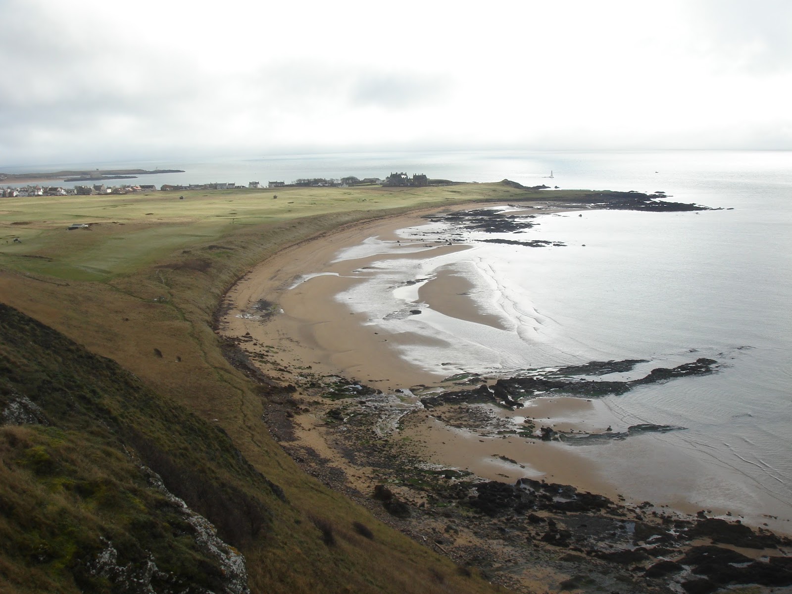
Gullane Sands


Once again I am the only person on the beach as its probably too far for most people to walk, there is a good path that leads me around the bay and as a bonus the tide is on it way out. I made my way around the bay and took a picture of the small islands just off the Brigs of Fidra.

North Dog and South Dog

As you can see the islands are called North and South Dog, North Dog is the one on the left with the lighthouse. The bay leads onto Broad Sands and because the tide is out I can walk "route one" all the way to North Berwick.
            I stop in North Berwick for a sandwich and finally the sun makes an appearance, so as a reward I treat myself to an ice cream. :)
            There is a road out of North Berwick that follows the coast and it soon turns into a coast path, eventually the path runs out and I find myself making it up as I go along, I manage to scramble over a dry stone wall which leads onto the A198, even though its an "A" road its nice and quiet on this Sunday afternoon.  The "A" road takes me down to Castleton where the impressive Tantallon castle resides.

Tantallon Castle and Bass Rock
As you can see I managed a nice photo of the castle and Bass Rock, they look really close on my photo but Bass Rock is a good mile or so out at sea.
              Not long after Tantallon Castle the road takes a left and then becomes a track taking me around the bay at The Gegan this in turn takes me down to Peffer Sands, eventually I have to head inland along a dead straight road called Lime Tree Walk I really dislike roads that are this straight as they seem never ending. After turning left at the end of the road I finally make it to the village on Tyninghame this where I should have stopped for the day as even by now my feet and legs were starting to scream at me, but instead I carried on! Just after Tyninghame the John Muir Way makes a welcome return to the coast after its meanderings in the Scottish fields of West Lothian, I followed the path to the coast and cut across the beach at Dunbar (as I had spotted a footbridge near the golf course). Finally I arrived into Dunbar at the end of my day, thoroughly knackered but at least tomorrow was a nice easy day.

Accommodation: Air BnB, A nice house and they made me feel very welcome but the bed was far too small for me. :(

Friday 18 March 2016

Walk 222

Dalmeny to Seaton Sands 22.5miles

I stopped for breakfast at the hotel under the Forth Rail bridge, as I sat there I reflected on what had been a fantastic few days walking the Fife Coast Path, it had been a long time since I had walked along a continuous coast path and not had to head inland or walk through farmers fields (with me usually getting lost!) it had been a real treat.

I was now back to "making it up as I go along" which is OK with me.  I started today by walking around Peatdrught Bay and then heading east past Dalmeny House.
Dalmeny House
The path eventually ends at the river Almond and you have to walk the irritating 2.4 mile up stream and down stream to get back to the coast, it may have been irritating but it was still one of the nicest detours I have ever taken.
River Almond Weir
Once I was back on the coast the boardwalk was wide and full of roller bladers, cyclists and joggers....I thought I must be near Edinburgh.
         Scotland's capital loomed large in the distance with the peak of Arthurs Seat sitting proudly in the middle of the hustle and bustle. I skirted around the outside of the city via the Port of Leith and eventually arriving in Portabello with its fabulous sea front.
Portabello Beach
Not long after Portabello is the town of Musselburgh where I picked up a new coast path The John Muir Way, this path would take me all the way along the coast past Dunbar, occasionally it heads inland but most of its route is along the coast.  The final few miles to Port Seaton were along the new coast path and I eventually arrived tired and hungry at my accommodation for the night.

Accommodation: Wemyss Hotel, 18 Links Rd. Port Seaton £25.00 RO It was OK for the price.

Thursday 17 March 2016

Walk 221

Dysart to Dalmeny 22miles

Dysart
Today was my last day stopping with my daughter in St Andrews, it had been a lovely visit and I will never tire of visiting both her and the town.

I arrived in Dysart at my start point with my full pack on my shoulders again, it had been a nice few days without it but after a mile or so I didn't really notice the extra weight.
I made my way to Kircaldy, this must be one of the biggest towns I have walked around since Aberdeen, so much traffic and people! This town was closely followed by Kinghorn which at least was a little more sedate.
Kinghorn


Burntisland quickly followed Kinghorn and as the tide was out I was able to hop onto the beach and walk all the way into town.
Burntisland Beach

As you will be able to see by the pictures there was a lot of very misty low cloud around the bays, which was a real shame as I had to cross the Forth Road Bridge and I was nearly on top of it before I could see it!

Forth Road Bridge

Forth Rail Bridge
The walk across the bridge was fantastic though a little unsettling as every time a large lorry crossed the bridge the whole structure bounced up and down!!  All to soon I arrived in Dalmeny and my train back to Inverkeithing.

Accommodation: Boreland Lodge Hotel. Inverkeithing £30.00 bed only.  A very nice stay with a larger than normal single bed.

Wednesday 16 March 2016

Walk 220

Pittenweem to Dysart 23 miles

The start of the walk took me towards St Monans and its splendid windmill, I hadn't seen one in as good as condition since my travels through Norfolk/Suffolk.
St Monans Windmill
The weather was improving a little today and I actually caught a glimpse of the sun as I walked through Elie and onto Earlsferry.  There is a nice hill just after Earlsferry that gives you a great view over the bay and the golf course.
Earlsferry Links
I edged my way along the coast eventually arriving in Leven and closely followed by Methil, the least I can say about these 2 towns the better! I navigated my way around the wastelands and docks and soon enough I was on the open coast again heading towards East Wemyss and its castle.
East Wemyss Castle
I soon arrived in Dysart and my bus home, it had been another nice walk again today with plenty of this to see along the way.

Tuesday 15 March 2016

Walk 219

St Andrews to Pittenweem 21miles

The grey mist had descended on my walk again as I made my way out of St Andrews.  Today was to be a full day of hugging the coast along paths the likes I hadn't seen for many a mile.

St Andrews Beach


The path wound its way around the coast up and down I went, scrambling over rocks (this part of the FCP is tidal) walking along empty beaches, it was just sheer bliss.  After a few miles I came upon Buddo Rock named I presume because it actually looks like and image of Budda. You need to look carefully....and maybe squint your eyes a bit!!!
Airbow Point

Buddo Rock


The path just before Boarhills cuts inland, but thankfully all too soon I was back on the coast path passing Airbow Point and then skirting around yet another golf course at Kingsbarns.  I walked onto to Craighead and and the coast path took a right turn heading in a westerly direction, which was nice because the easterly wind was now at my back, the path dropped down the coast to Crail. Crail was the first of a succession of really lovely small coastal villages along the south coast of Fife, after Crail came Anstruther with its famous Fish and Chip shop, apparently people come from miles around to sample their food, unfortunately it was closed when I arrived :(
                   I only had a couple of miles before arriving at my final destination of the day at Pittenweem, today had been a great walk along some reasonably hard terrain but a walk I'd like to do again when the weather is much nicer.

Crail


Monday 14 March 2016

Walk 218

Tayport Bridge to St Andrews 17miles

A nice easy days walk today starting with a bus ride to the Tayport Bridge, the sun was out again which was very nice to see.
Tayport Lighthouse
I had now picked up the Fife Coast Path which starts inland at Newburgh and finishes at Kincardine, I was only going to walk the Tayport Bidge to Inverkeithing section which is more or less most of it!
                The walk took me along the Tay estuary until I reached the village of Tayport, here I headed into the forest of Tentsmuir which was just lovely to walk through, everything was so quiet.
The path eventually lead me out of the forest to Leuchars and onto Guardbridge.  The road in Guardbridge had been blocked at one end due to Gas works, it was surreal walking along what is usually a very busy road, I even stopped and talked to a local man who was cutting his hedge and commented on how nice and quiet it was along this road, he was loving the peace and quiet.
                   All too soon I was back on the busy A91 heading full steam to St Andrews, I stopped briefly to take a picture of the golf course but as this is my 6th visit in the last 2 years I've seen everything that needs to be seen in this beautiful town.

St Andrews

Sunday 13 March 2016

Walk 217

Arbroath to Tayport Bridge 21miles

I was feeling tired this morning, and as I walked along the seafront at Arbroath my legs felt like there was lead weights tied around them, I have always found on these walks that day 3 or 4 are the hardest and today was the day! Though you will notice one thing from the picture below, and that is Blue Sky!! yes the sun finally made an appearance!!
,
Arbroath Beach

                I had to head a little inland at the start as (or so I thought) there was no path along the front and therefore I had to walk along the cycle path next to the A92, it transpires that there is now a brand new cycle path that takes you from Arbroath to Dundee hugging the coast which are not marked on any OS map..... yet!.
                So I trudged wearily along the coast passing through Carnoustie, Golf St and Barry, I had wanted to walk around Buddon Ness but due to the MOD red flags flying I was unable to, this did surprise me as it was a Sunday but you could hear the pop, pop pop in the distance of gunfire. The cycle path carried on through Monifieth and onto Broughty Ferry with its magnificent castle.
Broughty Castle
I walked on through the industrial areas that lined the docks around this area and finally arrived in Dundee, this is where things went a bit haywire!  I wanted to walk across the bridge towards Tayport but bizarrely I couldn't find a way onto the bridge for pedestrians,. I had noticed much to my dismay that there were signs up either side of the road carriageways stating "no pedestrians or cycles on the bridge" after searching for 20mins for a way onto the bridge I just gave up, I had by now had enough of this walking malarkey and I just wanted a sit down.  I walked back into Dundee and caught the bus, as I sat on the bus I decided to see if there was a way across the bridge for walkers etc and much to my annoyance there was!! the walkway was in the middle of the 2 carriageways!!! I must have walked past the entrance 3 times and just not seen where to walk!! So, I got off the bus and walked back into Dundee and caught the bus back to St Andrews for my 3 night stay with my daughter who is at the University.


Saturday 12 March 2016

Walk 216

St Cyrus to Arbroath 24miles

There is another good cycle path that took me over the county border from Aberdeenshire to Angus. Once over the border I walked along the cycle path until I was able to cut through some woodland to reach the beach, and what a beauty! I was beginning to miss my beach walks and even though this one was over in a matter of a few of miles I really enjoyed the feeling of sand on my boots again.
Montrose Beach
I quickly made my way through Montrose stopping only to stock up on essential supplies (sandwiches etc!) I then made my way along the road to another of my favourites "the Lighthouse", the one at Scurdie Ness is like a lot of lighthouses these days and is privately owned,  I mean who wouldn't not like living in a lighthouse? sheer bliss for me!!
Scurdie Ness Lighthouse
Once I'd passed the lighthouse I followed a track to the Mains of Usan and then picked up a quiet road that took me to Lunan.  I stopped for a bite to eat in the grounds of the castle at Red Castle.
Red Castle

After lunch I took on the 2 mile walk along the beach at Lunan finishing at Corbie Knowe where I picked up a farm track that took me all the way to Auchmithie, according to the waymarkers I was now on the Angus Coast Path which like a lot of these paths is not marked on my map.
At Auchmithie the track turns into a great coastal path that is well maintained and the views are spectacular.
Carlingheugh Bay

Castlesea Bay

The 5 miles from Auchmithie to Arbroath was a real treat and it even had my 3rd " don't walk along the coast sign/warning" which in true tradition I chose to ignore and I'm still here to tell the tale!!!

Accommodation: Blairdene Guest House, 216 High St. Arbroath £35.00 BnB Nice but a little bit strange!!!


Friday 11 March 2016

Walk 215

Stonehaven to St Cyrus 23.5miles

The day was grey again and this was to be the theme for most of the next 10 days. I made my way out of town largely uphill and took a picture of the bay.
Stonehaven
I followed a path around the bay via Downie Point and headed full steam towards my highlight of the whole 11 days....Dunnottar Castle, I had been looking forward to seeing this castle for the last 200 miles and I wasn't disappointed! Its just amazes me how they managed to build such a fantastic castle with so little technology and equipment, its just mind blowing!!
Dunnottar Castle


Dunnottar Castle

I carried on around the bay at Dunnottar following an unmarked path until I reached Gallaton where I cut inland and picked up the A92 this was quite a busy road but I soon branched off and headed towards Crawton. At Crawton I cut inland again via a farmers field! and picked up a small minor road and this eventually took me to Inverbervie. Thankfully from Inverbervie there is a great cycle path that hugs the coast taking me through Gourdon and Johnshaven. I stopped at the pub for a cuppa in Johnshaven and to ask the "locals" about the rest of the route along the coast (this I have found is always a good way of getting a good idea of what lies ahead!) they poured over my maps and told me that I could get all the way around to St Cyrus, the only tricky bit would be around the caravan park at the Milton of Mathers.  So I carried on towards St Cyrus, picking my way through the shingle beach at the caravan park eventually arriving at my second "do not use the coast path as it may be unstable" sign of the week! I of course ignored it and carried on via a very precarious looking castle at West Mathers.
West Mathers Castle
From the angle I took this photo you can't appreciate how this castle is hanging onto the cliff by its fingertips! one big storm and this will be a goner!!
            I was glad I ignored the warning sign as I was able to get a great view of Montrose bay just before heading downhill and my accommodation for he night at Nether Warburton.
Montrose Bay
Accommodation: Eskview Farm, Nether Warburton £45.00. Very nice and very quiet!!


Thursday 10 March 2016

Walk 214

Aberdeen to Stonehaven 21.5 miles

I restarted my walk from the bus station in Aberdeen and there to meet me was fellow coast walker Andy Phillips. Andy had got a little further along the coast than myself so we walked around the harbour chatting until it was time for him to catch the bus to his start point at Nigg Bay.  I carried on around the bay at Aberdeen following a good track all the way to Girdle Ness and its lovely lighthouse.
Girdle Ness Lighthouse


Next stop was Nigg Bay with its great beach, here I stopped for a cup of tea and waited for Andy and waited and waited, after 20mins I carried on walking, I guessed he must have carried on ahead of me!
Nigg Bay


 Not long after Nigg bay there was a sign for the Aberdeenshire Coast Path (which wasnt marked on my map, again!) so I decided to follow the signs, just before Greg Ness there was/is a sign informing you that the path is closed due to a landslide, looking at my options of either walking along a very busy road next to a railway line or walking the senic coast route I chose the latter!! (I thought I could just wing it by climbing over the farmers fence if the landslide was that bad, as it turned out it was just a small step over a bit of mud!!!!)  The walk to Cove Bay was really nice with plenty of Geos and great views, all to soon the path came to an end so I stopped and asked a local if I could go any further along the coast but I was unable to do so due to a big quarry at Colsea Yawn.

Long Slough


Burnbanks Haven
At Cove Bay I bumped into Andy again, we had a chat about the route so far and then walked out of the village via the cycle route, it was a bit uphill out of the village and due to my long legs I carried on ahead of Andy.  The road wound its way past the quarry at Colsea and the village of Findon, eventually I turned off towards Porthlethen Village, here I picked up the Old Coast Road which was basically a farm track but it was nice to think that once upon a time this was the main road along the coast. I asked someone in the village if I could walk all the way to Newtonhill along this road and they said "yes" however a car pulled up next to us and they said "no" as the bridge over the river at Newtonhill had been washed away in the winter floods, but the overall opinion was that it should have been repaired by now so I carried on regardless!!  The track took me through Downies and past Clashfarqher Bay and then eventually down hill towards the bridge/non bridge, as I turned the corner I could here rushing water and there was the bridge, hooray!!!! (and a splendid job they had done repairing/replacing it!!)  I climbed to the top of Newtonhill to take in the views and eat my sandwich.
Newtonhill (you can just see the bridge as well!)
I now had to walk out of town and pick up the very busy A90 for a few miles towards Stonehaven, fortunately there is a very good footpath alongside the road and it wasn't long before I branched off along a much quieter road and the final few miles into Stonehaven.  Overall a really nice days walk and the sun came out eventually!!
Stonehaven
Accommodation:
Belvedere Hotel 41 Evan St, Stonehaven £45.00. Very nice hotel.